- Home
- Products
- Air Quality Monitoring
- EarthSense MappAir®
EarthSense MappAir®
High-resolution air quality modelling and forecasting
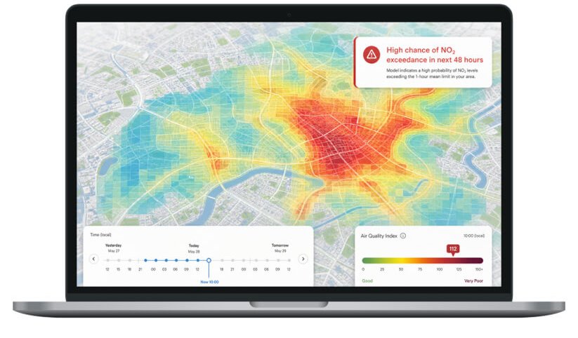
MappAir® from EarthSense turns emissions, weather, monitoring and other environmental data into continuous air quality maps, helping organisations understand, predict and respond to changing conditions.
Air quality changes street by street and hour by hour. Monitoring gives trusted measurements at specific locations, but it cannot show every road or neighbourhood. MappAir® fills those gaps by modelling air quality between and beyond monitoring locations, so you can understand pollution patterns, forecast conditions and identify what is driving poor air quality. Model outputs can be viewed in MyAir® alongside Zephyr® measurements.
What the model includes
- Road transport: traffic emissions from cars, buses, HGVs and motorcycles across the road network.
- Non-road sources: shipping, ports, rail and other local sources.
- Domestic heating: emissions from residential heating and solid fuel burning.
- Background pollution: regional and long-range pollution from wider environmental datasets.
Features
- High-resolution maps: continuous air quality maps with historical, current and forecast views.
- Forecasting: predict air quality up to 48 hours ahead to support planning and operations.
- Source attribution: understand the contribution of transport, industry and background pollution.
- Data integration: model outputs delivered through APIs, GIS and data services.
How MappAir® works
- Emissions model: transport, industry and other sources are combined into a detailed emissions inventory.
- Atmospheric dispersion model: weather and atmospheric conditions simulate how pollutants move and disperse.
- Calibration and validation: monitoring data calibrates and validates the model outputs, improving confidence in local predictions.
MappAir® supports clean air strategies and policy in local government, environmental compliance in industry, dust impact forecasting on construction sites, protection of schools and vulnerable communities during pollution episodes, and evaluation of transport schemes.
0 products selected